Thursday, July 31, 2014

HIKING THE GIANT!

Mount Giant is considered the "giant of the valley" for those in the Keene Valley. It's huge size can be seen from several surrounding peaks, standing at 4626 feet above sea level. The trailhead is easily accessible from Route 73 just outside of St. Hubert's. There are three trails that lead to the summit. Roaring Brook trail is closer to St. Hubert's and is 0.5 miles longer. There is a much lengthier route from New Russia which is closer to 7 miles one way. I chose to hike the Chapel Pond route because is the most sce. We parked at Chapel Pond and walked to the trailhead on Route 73.


After signing in at the hiker's log book, we started up the mountain. It's a gradual climb with several switch-backs but overall an easy start. David and I were pretty sore from the day before but we were able to maintain a steady pace. The weather forecast for the day was partly cloudy although it seemed to be mostly cloudy when we started until later in the day the sun finally broke through. Most of this trail is climbing the ridge line, therefore we had several great lookout spots as seen in the photos below. 
First lookout--Great Range in the distance; Route 73 below

First lookout--Chapel Pond

First scenic break


Washbowl 

Bridge at Washbowl

Panoramic view--Washbowl in the foreground (second lookout)

We stopped at every lookout point to enjoy the views and hydration. About an hour and 45 minutes into the hike we came to the 0.7 marker. At this point the trail became flatter and it was a pleasant feeling for the joints. Shortly thereafter we came across these signs and we really didn't know which was a better choice out the two. On the ascent we chose OVER BUMP and on the decent we chose AROUND BUMP. We then realized that the trails come together further up but it was a matter of walking around or over a large rock outcropping. There are some nice views of the final ascent if the OVER BUMP route is chosen. Better to use AROUND BUMP when descending.


At last we came to the final intersection before the summit. Later we will make a turn here to hike over to Rocky Peak Ridge mountain.


Once at the summit we were amazed at the great views even though most of the peaks appeared hazy. After a few summit photos we found a nice spot to sit down and enjoy a nice break before the next challenge of the day. 


Official geographic seal at the summit

David overlooking the Keene Valley

Looking straight down at the valley

Rocky Summit

Looking back at ridge trail

Breezy and chilly at the summit

Ausable Club


(Left to right) Jim, David, Alex, Nate


 Right: Dix mountain Left: Nippletop

(Foreground) Great Range (Background)left: Marcy center: Colden right: Algonquin & Iroquois 

HIKE TIMELINE
Chapel Pond Trailhead: 0745
Giant Summit: 1007
Break

Left Giant: 1046
Rocky Peak Ridge Summit: 1150

Left Rocky Peak Ridge: 1236
Giant 2nd time: 1330
Left Giant:1343
Chapel Pond Trailhead: 1530

HIKE SUMMARY
Date: July 2014
Weather: 71 at trailhead, low 60's at summit
Elevation Gain: 3000+ ft

ADK 46er TALLY

#18 Giant (4626 ft) #12/46


Wednesday, July 30, 2014

HIKING ACROSS BEAR DEN MOUNTAIN

(continuation from the previous post)

The easiest way to reach the Lake Road from this part of the hiking trip was to continue hiking north across Bear Den mountain which stands at 3399 feet above sea level. Bear Den mountain is not one of the 46 but nevertheless a good size mountain. It was 1.3 miles from the Dial summit. At this point in our hike we just wanted to get back to the Lake Road before complete darkness. We reached the tree covered summit in 45 minutes were we found these two signs. After a couple photos at the summit we began the final descent to the Lake Road.


Little did we realize that we still had a couple of hills to cross before the final descent. There was 2.5 miles between us and the road with only less than one hour before sunset. We came across the area where a fire burned a beautiful birth glade in 1999 when an immature hiker started a fire near the trail. It took firefighters and professional sawyers 10 days to put it out. The trail goes right through 8-9 foot saplings that are now grow in the ash covered soil. It is also among a massive rocky bluff that over looks the valley. David and I took a 5 minute break as we watched the sunset over Upper Wolf Jaw. 
Sunset a minute prior taken photo


When David and I saw this sign on the stump of one of the chopped birch trees in the fire line cut during the fire we literally ran the 1.7 miles down the mountain in 25 minutes. We came out at the Lake Road next to this sign "H.G. Leach Trail to Dial and Nippletop".  


We made it to the Lake Road at the point when a flashlight should be used but since we were on the road we enjoyed the walk in the darkness. At the Ranger cabin we checked out at 8:57 pm. 

Back in Keene Valley we quickly realized that all the restaurants and cafe's had closed for the night so we made a quick trip into Lake Placid for some chicken wings and garlic bread. When we came back Nate and Jim had arrived and were waiting for us. 

HIKE TIMELINE

Parking Lot: 1250
Gillbrook Cut-off Trailhead: 1402
Elk Pass Trailhead: 1511
Nippletop Summit: 1639

Left Nippletop Summit: 1720
Dial Summit: 1820

Left Dial Summit: 1844
Bear Den Summit: 1927
No break

Checked out: 2057

HIKE SUMMARY

Date: July 2014
Duration: 8 hours
Elevation Gain: 3200 ft

Tuesday, July 29, 2014

HIKING MOUNT DIAL

(continuation from previous post)

The next step of the adventure was making it to the next summit. When hiking a mountain range it only makes sense to hike the next mountain instead of doing one at a time. The next one was Dial mountain 1.9 miles away.


There is almost 600 foot difference in summit elevation between Nippletop (4593) and Dial (4003). The decrease in elevation in theory is always a good thing but there was at least 3 hills between the peaks. We were able to hike the 1.9 miles in one hour. The summit was more to the western side of the mountain and therefore provided amazing views of the entire Great Range. 

Looking back at Nippletop in the far horizon

Looking at Ausable Valley

Summit over looking valley

Official summit photo

(foreground) Blake and Colvin (background) Great Range 

David 

Brothers on Dial

We enjoyed a shorter break on Dial, realizing that we are going to be competing for sunlight in less than 2 hrs from now and we had a lengthy return to the Lake Rd. via Bear Den mountain. 

HIKE TIMELINE

Parking Lot: 1250
Gillbrook Cut-off Trailhead: 1402
Elk Pass Trailhead: 1511
Nippletop Summit: 1639

Left Nippletop Summit: 1720
Dial Summit: 1820

Left Dial Summit: 1844
Bear Den Summit: 1927
No break

Checked out: 2057

HIKE SUMMARY

Date: July 2014
Duration: 8 hours
Elevation Gain: 3200 ft

ADK 46er TALLY

#17 Dial (4003 ft) #42/46

Monday, July 28, 2014

HIKING TO MOUNT NIPPLETOP

Every time I plan a hiking trip to the Adirondack high peaks there are several important factors that have to come together fairly well for the trip to actually happen. The following are increasing in the level of importance. First is the time off from work. Second is a hiking buddy or buddies. Third is family arrangements. And fourth, most important of all, is the weather. Nevertheless, with all of these factors inline, my next hiking trip became a reality.

The hiking group included Nate (work colleague), Jim (Nate's friend), my brother David, and myself. David and I came up earlier on Friday to squeeze in an extra hike, while Nate and Jim came up later on Friday night.

There are three ways of getting to the high peaks from Syracuse and I have tried two out of the three so far. This time I decided to try a new route going through Rome, via 365 East, 8 North and then 87 North. In conclusion this will be the preferred route from now on.


We drove into Keene Valley at noon and decided to check into the Ausable Inn before we went hiking just in case we returned really late. After a quick check it was a 5 minute drive to the hiker's parking lot 0.5 miles from the Ausable Club. It was a nice warm-up walk to the Lake Road where we signed hikers log.


After a few words with the ranger and a couple quick photos at the wooden gate/arch we set out at a good pace to the Gillbrook Trail Cut-off where we started our initial ascent to the Elk Pass.


Half a mile into the hike on Gillbrook we came to this intersection. The trail was easy with minimal rocks. At this point we didn't weren't sure if we would take a detour to Fish Hawk cliffs and Indian Head.


Shortly, 0.2 miles, we came to another intersection. After looking at the map, a detour of 1.4 miles to the cliffs and Indian head would probably add another hour to our hike and leave us hiking in the dark, so we decided to skip it this time. This little scenic detour would be great when hiking Mt. Blake and Colvin. 


We came across this little campsite just below 3500 feet on our way up. I have never tented in the high peaks before but it may be a good idea for the future. 


Taking a break for a quick second breakfast of a Quest Bar, Powerade, and Succeed Caps. 


For previous hikes I mounted my GoPro to a chest harness but this time I mounted it to the hiking pole and it was very convenient to turn it on/off and take some short videos along the way. 


This was quite the show the trail--a snake dragging a toad off the trail and into the brush. We stayed and watched as nature took it natural course of predator and prey. 


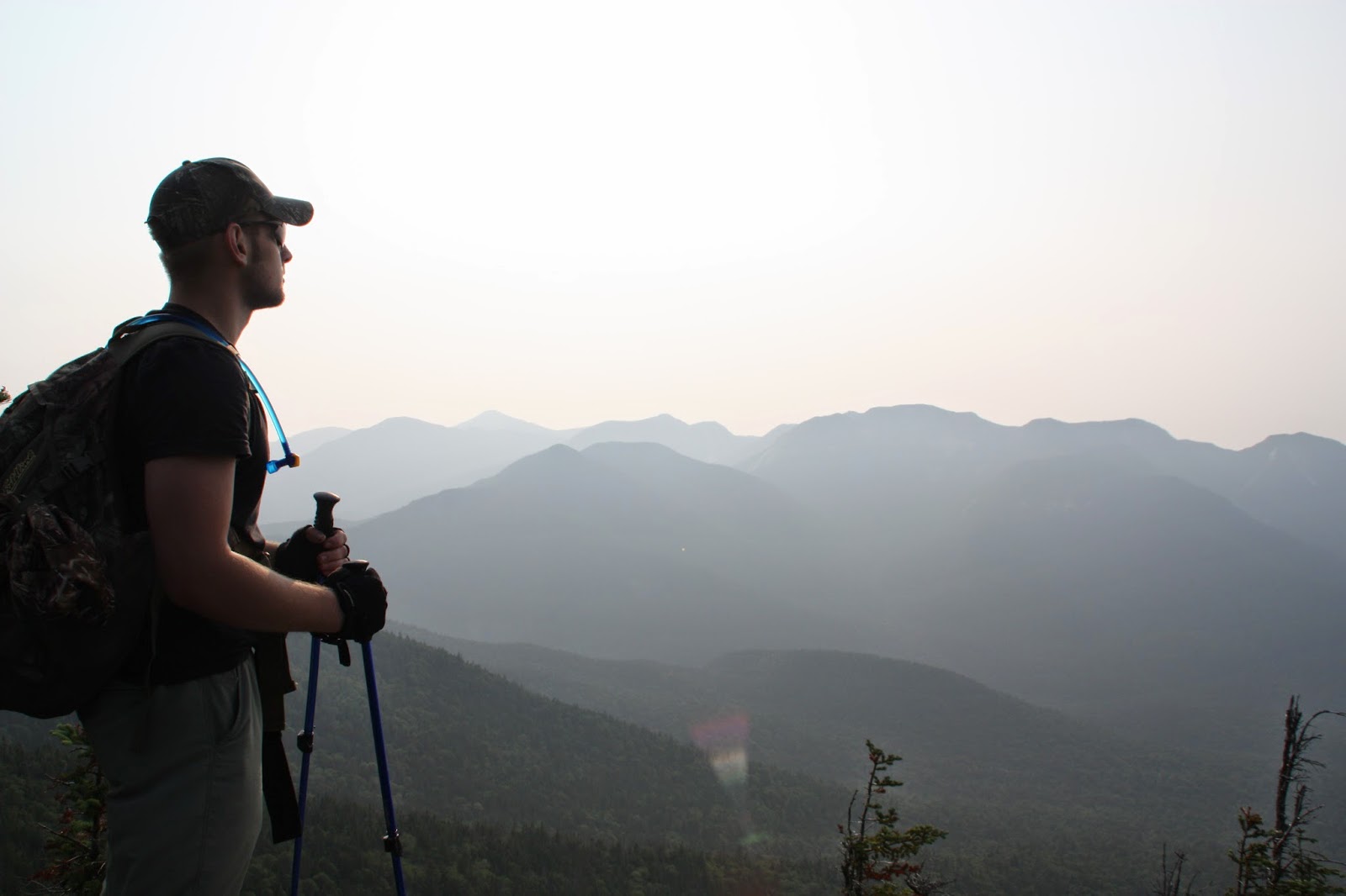
Two hours into our hike we came to Elk Pass. This was the steepest part of the hike, a 1300 feet vertical rise on the western part of Nippletop Mountain. We met a couple making their way down who complained about hurting knees. After a slow hike for 1.5 hours we came to the intersection that indicated Nippletop summit was 0.2 miles to the right. Another 5 minutes of walking brought us to the summit and its spectacular views. Although the views were hazy, it was easy to distinguish the different peaks on the horizon.  


(Looking down Nippletop--slide to the left)

(center) Gothics and Armstrong (foreground) Sawteeth 

(center left) Upper Wolf Jaw (center right) Lower Wolf Jaw

(left) Blake (right) Colvin

Nippletop Summit (anchor in front of left boot)

David enjoying the views

(background left) Giant (background right) Rocky Point Ridge

Dix Mountain

After enjoying the views, eating a lunch (chorizo, bread and tomato) and relaxing we were ready to tackle the next part of the hike, Dial Mountain. We also met another hiker who was doing the Colvin Range (Blake, Colvin, Nippletop, Dial, Bear Den). For the remainder of the hike we didn't see any more hikers. 


HIKE TIMELINE

Parking Lot: 1250
Gillbrook Cut-off Trailhead: 1402
Elk Pass Trailhead: 1511
Nippletop Summit: 1639

Left Nippletop Summit: 1720
Dial Summit: 1820

Left Dial Summit: 1844
Bear Den Summit: 1927
No break

Checked out: 2057

HIKE SUMMARY

Date: July 2014
Duration: 8 hours
Elevation Gain: 3200 ft

ADK 46er TALLY

#16 Nippletop (4593 ft) #15/46