Tuesday, July 21, 2015
Friday, July 17, 2015
HOUGH MOUNTAIN--AN UNMARKED TRAIL!

The second part of the trip was hiking Hough (pronounced "huff") mountain. It is considered an unmarked trail or primitive trail mountain because it isn't officially marked with color coded trail markers nor is the trail maintained by the Adirondack Mountain Club. There were a couple hikers who had written blog posts about the difficulty of the unmarked trail. However, the trail from Dix to Hough is well used and therefore could be easily followed.
Coming down the Beckhorn there are two trails, one leading to the right and the other left towards the ridge leading up to Hough. The unmaintained trail is very noticeable because its very brushy and narrow. It was a very warm day and therefore we all wore shorts and short sleeve shirts exposing more skin to potential scrapes and scratches. We got away with mild scratches. The trail itself is packed soil coated with pine needle coated. The descend down to the col was easy on the feet.
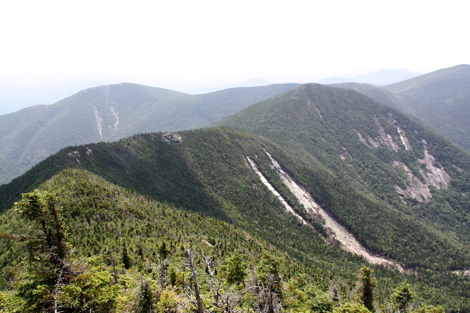
Along the way, there were 3 small rock outcroppings where we stopped for a few minutes to enjoy the views looking back at Dix mountain as well as appreciate the slide coming down Hough. During this part of the hike, Dima and I ran out of water and we couldn't find any along the trail.
The final ascent to Hough was moderate with an occasional steeper rock climb. For the most part the trail zigzagged up the mountain. The 1.3 miles from Dix to Hough took us about 50 minutes.

Hough slide from trail leading up to Beckhorn

The summit is tree covered except for a couple larger exposed rocks. We took a few photos and relaxed for about 20 minutes and started heading down the other side of Hough towards Lillian Brook. On the trail we ran into a couple female hikers coming up to Hough, their third summit of the day. Both of them looked pretty exhausted and they had 2 peaks to conquer as well as hike back to the Elk Lake parking lot.


Dix-Hough col


Peak #24 for me
Once we descended to the col between Hough and South Dix (aka Carson Peak) we were faced with 3 potential trails. One heading East towards East Dix, another South towards South Dix, and yet another Northwest towards Elk Lake. The northwest trail was marked with a cairn. At this point in the hike I decided to verify the direction by looking at my Garmin GPS. It indicated towards the northwest trail marked with the cairn and therefore we continued down that trail.

Twenty minutes on the trail we came to a small brook that fed into the Lillian Brook, so we decided to fill our empty water bladders. I had the opportunity to try out the new Katadyn Hiker Pro water filter. It worked really well and we had our 3 containers equaling 7.5 liters of water filled in under 5 minutes.
The trail conditions were very muddy at times once we got to the Lillian Brook. But it was easy walking with minimal rocks. It was almost 2 miles from the Hough summit to the bottom of Brook trail.
On the way back to the car, we decided to stop by the Slide lean-to. It was newly renovated, with the smell of new fresh wood. Andrey and I exchanged some old memories of past hikes and the lean-to's we stayed in before.

Eventually we came to this sign on the road which quickened our pace even more. Although the 0.3 sometimes feels like forever when nearing the end of a long hike.

Overall the hike went really well. It was Dima's first two ADK peaks and it made a positive and lasting impression upon him. Maybe one day he will aspire to become a ADK 46er.
Trip Timeline:
July 12, 2015
Elk Parking Lot: 7:03 am
Slide Lean-to: 7:50 am
Lilian Brook: 8:14 am
Dix trailhead: 8:49 am
Beckhorn: 10:35 am
Dix summit: 10:43 am
Departed Dix: 11:32 am
Hough summit: 12:23 pm
Hough/South Dix col: 12:55 pm
Lilian Brook trailhead: 2:03 pm
Parking lot: 3:20 pm
Hike Stats:
#24/46 for me
13.2 miles
8 hrs 17 mins
2800 ft elevation gain
Video of hike to follow soon!
On our way home, we decided to stop by Cafe Adirondack because of the great Trip Advisor reviews. However when we reached the restaurant we found out it opened at 5 pm and so we decided to look for another place to eat instead of waiting for 40 minutes.
We went further up the road to a place called Black Bear restaurant. To make the long story short, the customer service was terrible and the food wasn't all that great. So we had some regrets about choosing this place and we definitely don't recommend it.

LOOKS CAN BE DECEIVING!!
Thursday, July 16, 2015
DIX MOUNTAIN: HALFWAY TO 46
Almost a month into summer, Upstate New York finally had a weekend that felt like summer, 80's and sunny. This also meant it was a good weekend to hit the high peaks in the ADK. So with a good weather forecast Andrey, Dima and myself set out on a day trip to the Dix mountain range. This was my first time venturing out to the North Hudson area, and therefore it felt more adventurous.
After doing some blog browsing, several hikers recommended getting to the Elk Lake parking lot before 7 am because it fills up fairly quickly. And so we left my house at 3:30 am. It's nice to drive early in the morning, with minimal traffic. We took the North Hudson exit off 87 North at 6:30 am. At the ramp we made a left turn on Blue Ridge Rd. After 4 miles we made a right onto Elk Lake Rd at the Elk Lake Lodge sign. The road is roughly paved for a couple miles with plenty of pot holes which then turns into an all gravel road. Eventually you drive up to a house on the left and then the gravel road narrows and goes over some hills for 2 miles to the parking on the left. There was a wooden sign standing in the road across from the house which stated, "parking lot full, park here." We decided to drive up the road anyways just in case we can save an extra 4 mile hike. As it turned out the parking lot wasn't even half full.


The hike started out really flat with gentle slopes for almost a mile. But because of recent rains, there was a good stretch of trail that was very muddy. In fact recent hikers chose to walk on higher elevations on both sides of the mud. We also noticed the number of streams and brooks that crossed the trail therefore contributing to some of the wetter areas. There were several bridges over larger brooks. With the increased amount of standing water, also meant a lot of bugs in those areas.


Just a little over 2 miles we came to the Slide lean-to which also has a trail that leads to the Macomb slide. There was quite the group of people just getting up at the lean-to that we decided not to stop by.


In about another mile we came to the two cairns marking the Lilian Brook trail leading up to the col between Hough and South Dix. On the way down from Hough we came down this trail.


We came to this official yellow marker on the tree that indicated the Buckhorn trail. There was another marker on different tree heading north which indicated the Hunters Pass trail.

For a short distance the trail followed a river bed which allowed for some significant elevation gain. We were 2 hrs into the hike at this point so we took short snack break.


The humidity and heat of the day caused for excess sweating. During the course of the hike I drank almost 5 liters of water. I was grateful to have a water filter on this trip or else it would have been a parching descent.


Nearing the Beckhorn we had a few rock scrambles/ climbs but with some thought and proper foot placement it was easily accomplished.


Looking back at the ridge that we just hiked

A rock outcropping just before the Beckhorn

The final ascent to the prominent rock on the Buckhorn

From the Beckhorn the summit of Dix was about 70-80 yards via a narrow brushy trail. Once at the summit we had a nice 30 minute break. A PB & J sandwich always tastes better on the mountaintop.
There was another hiker who got to the top just before us via the Route 73 trail. He thought the trail was a pleasant hike with several areas of exposed rock which allowed for great views.

Looking Northwest

Looking Northeast from Dix summit

Dix marker


Foreground: Nippletop Background: the Great Range

Background: Bigslide mountain

Just before starting back down towards Hough, another hiker and her two dogs, Ausable and St. Hudson, reached the summit. We spent a few minutes talking about the hike and then parted ways.


Beckhorn from Dix summit


Dix from Buckhorn
The ridge leading to Hough
In the photo above, the rock outcroppings along the ridge allowed for some great views of Dix mountain and the terrain down below, especially the slide.
A final look from high up at Elk Lake as we started out towards Hough.

Trip Timeline:
July 12, 2015
Elk Parking Lot: 7:03 am
Slide Lean-to: 7:50 am
Lilian Brook: 8:14 am
Dix trailhead: 8:49 am
Beckhorn: 10:35 am
Dix summit: 10:43 am
Departed Dix: 11:32 am
Hough summit: 12:23 pm
Hough/South Dix col: 12:55 pm
Lilian Brook trailhead: 2:03 pm
Parking lot: 3:20 pm
Hike Stats:
13.2 miles
8 hrs 17 mins
2800 ft elevation gain
Video of hike to follow soon!
Subscribe to:
Comments (Atom)